


Navigation: Home -> (gear icon)
The first time you run the app it will display a message in the status area that the configuration is invalid and send you to the configuration page:
Fill out the fields with information for your InReach device. Note that the app works with one device at a time.
The User Name and Password fields come from the web services access account you set up with Garmin.
The IMEI field identifies your specific InReach device. You can find it on the Devices page of your Garmin account. You’ll have to log in with your regular Garmin credentials to get to the page.
The Website field identifies the specific website used to access information about your InReach device. This will be provided when you set up your Garmin web services account. It’s also available at Garmin’s portal connect page (see these instructions for more details).
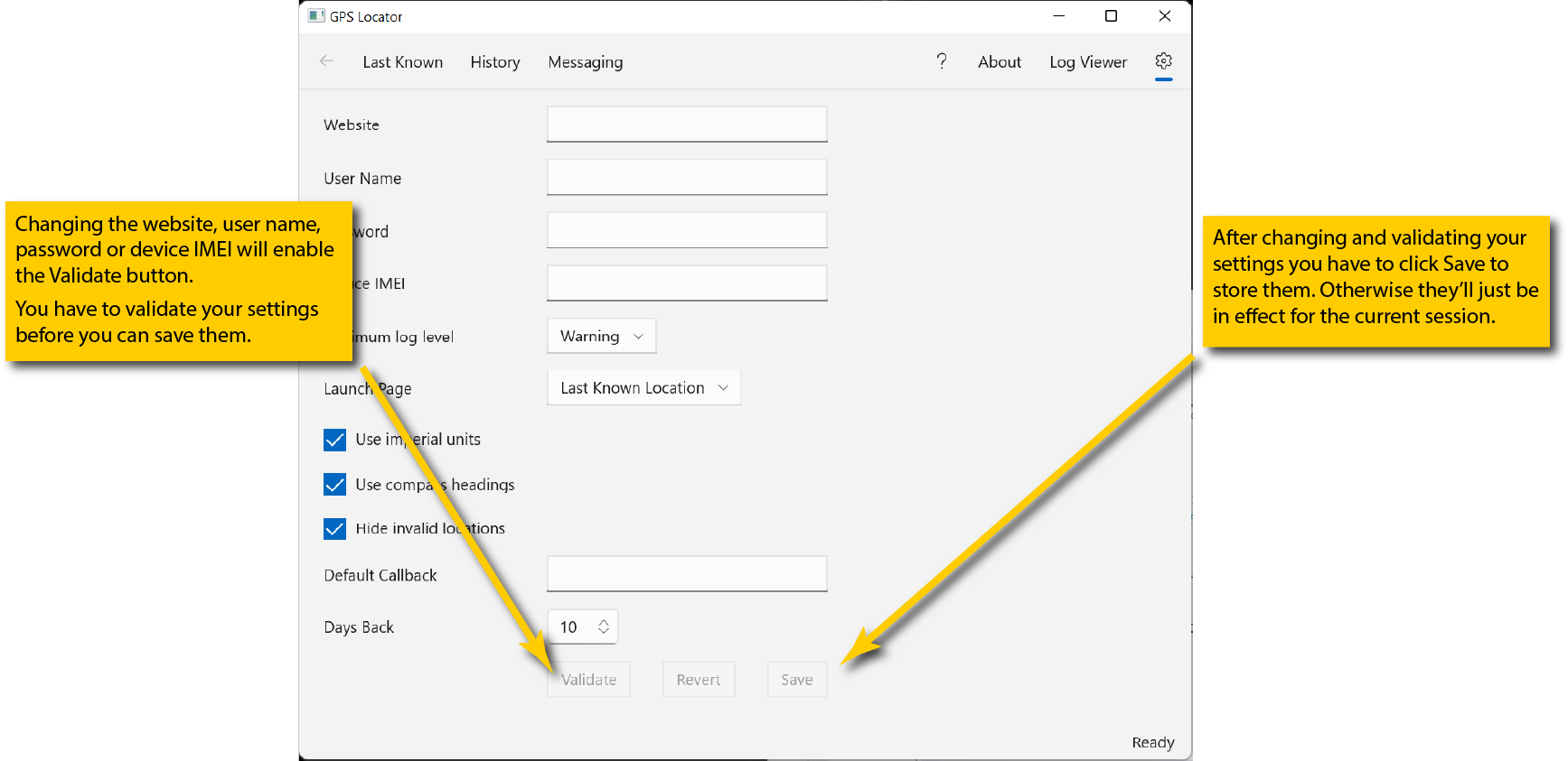
Once you have filled out the fields click the Validate button to confirm you have access. If validation fails check the website, user name, password and IMEI fields for errors and correct them. These are the only fields which need to be validated. If you change any of the other settings you can simply save the configuration by clicking the Save button.
Once you have successfully validated the configuration click the Save button to store the settings on your computer. They will be recalled every time you launch the app so you won’t need to re-enter them.
The Minimum log level setting controls the minimum level of log events displayed by the log viewer (see the documentation for the log viewer for details).
The Launch Page setting selects the page the app will open with when you launch it.
Checking or clearing the Use imperial units box sets the default for how altitudes and speeds are displayed. If checked, they’ll be in feet and miles per hour. If unchecked they’ll be in meters and kilometers per hour (which is the way the InReach actually records them).
Checking or clearing the Use compass headings box sets the default for how courses (i.e., directions of movement) are displayed. If checked they’ll display as compass headings (e.g., N, NNW). If unchecked they’ll display as degrees, with 0 being north.
Checking or clearing the Hide invalid locations box sets the default for whether or not invalid locations1 are displayed on the History and Messages pages. If checked invalid locations will not show up in the selection list. If unchecked they will show up.
The Default Callback field is the default “from” address that will be used for sending messages. It should be either an all-digits phone number or an email address. See the messaging documentation for details.
The Days Back field sets the default number of days of history and messages to retrieve. Garmin makes up to 31 days of tracking points, messages, etc., available for retrieval. See the history and messaging documentation for details.
return to documentation home page
The InReach system occasionally generates tracking or message points at latitude/longitude 0/0…which, unless you’re a very strong swimmer, are unlikely to be meaningful. ↩